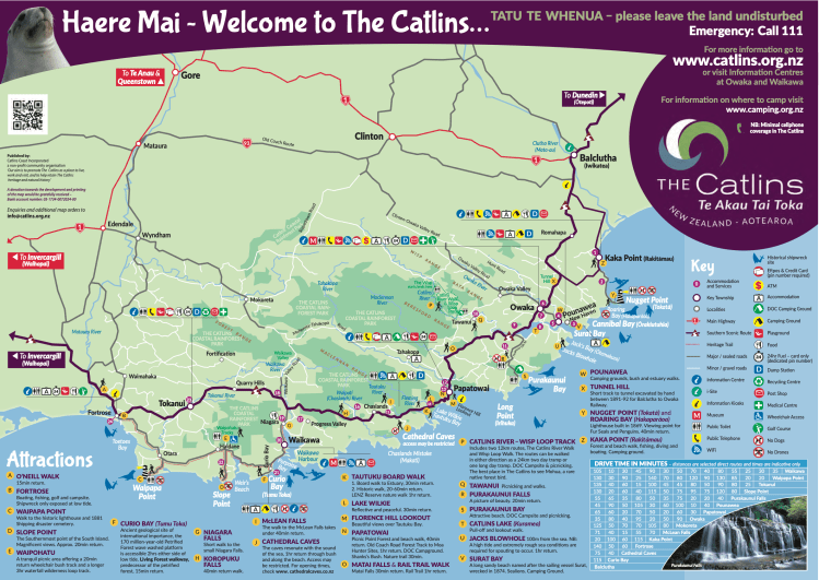
The Catlins is a coastal stretch along the bottom of New Zealand’s South Island. It boasts rugged hilltop landscapes, hidden waterfall walks and the odd shipwreck or two. The trip itself from start to finish, would roughly take 2-3 days and covers 26 different activities depending on how cut throat you are with your choices. A quick word of advice beforehand, most of the towns on the journey down to the Catlins are pretty desolate. I’d recommend making your petrol stops snappy and save more time for the coast – to put it into perspective; these places make Queenstown look like Times Square.
We managed to make the grave mistake of visiting point A – O’Neill’s walk. This is basically a 15 minute shuffle through an overgrown bit of forest and your only way back is to sprint through rows of long grass in the hopes you won’t come out the other side with a tick in your sock and a few cobwebs round your ankles. It doesn’t exactly express how scenic the rest of the journey is.
Point B takes you to Fortrose, it has a naturally overpriced cafe, petrol stop and some people are even able to spot the ship wreck off the shore, at low tide. Point C is Waipapa Point and here, you can spot sea lions lazing around on the beach overlooked by the old lighthouse. This is followed by point D, which is the Southernmost point of the South Island and a beautiful cliff top view. Waipohatu is point E and you can skip the 3 hour waterfall walk if you are on a time constraint and just do the tranquil 20 minute forest walk instead, to speed things up.

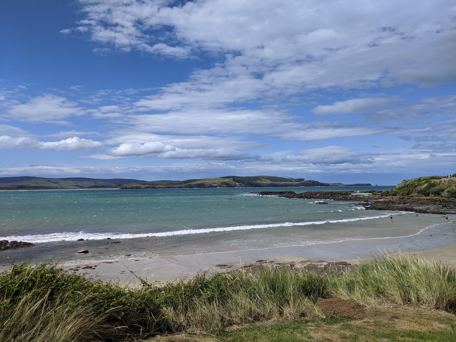
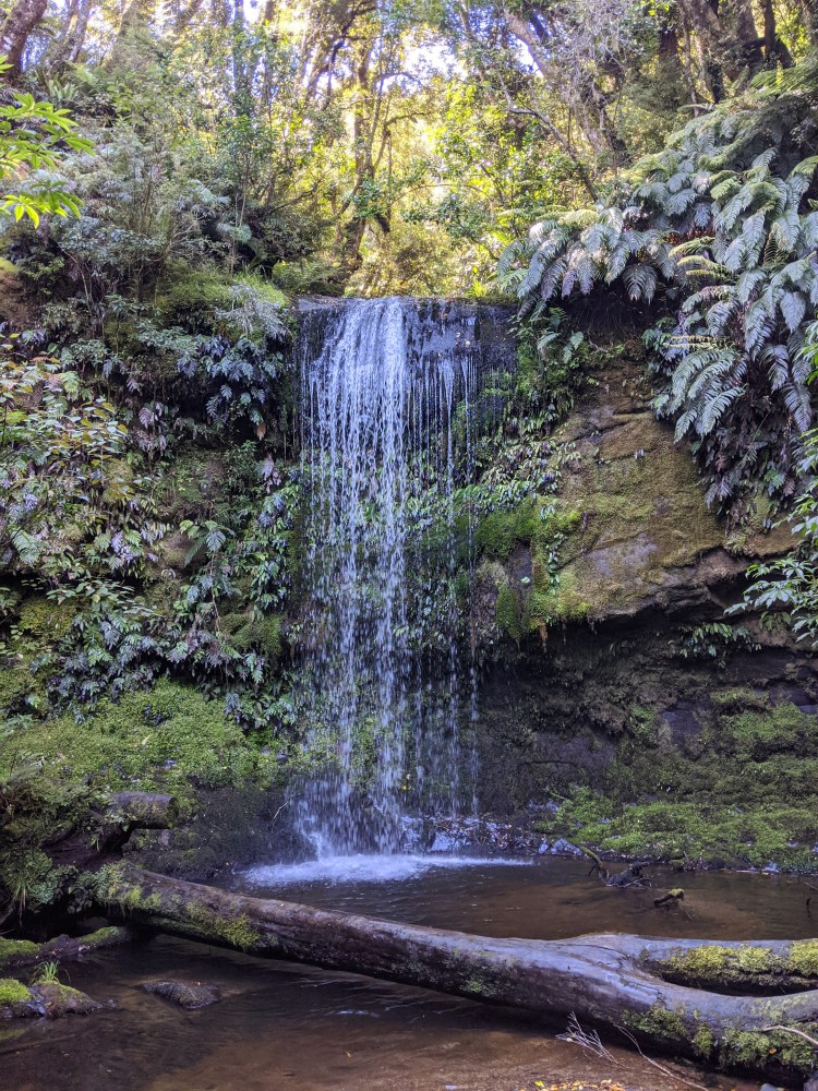
F is Curio Bay – a must see if you want to go for a quick dip and have the chance to swim with the local dolphins! The comically named Niagara Falls – point G, was titled this by the discoverer as a comparison to the famous landmark. This didn’t seem funny at the time when we pulled up by the side of the road to watch a quivering puddle. Again, I would personally give it a miss. However, Koropuku (H) and McLean falls (I) are both well worth the visit, with bush walks over rocky rivers in order to awe in their natural, hidden away beauty.
We were gutted to have missed Cathedral Caves (J), but this was down to the time of day we visited. Since this activity relies on the ocean tide, having a quick look over the tide timings would really be worth it so you can fit this stop into your itinerary. Attractions K – M are all within close proximity and easy to whip round, so I would recommend trying to see all of these as they only involve short walks/ are of easy access. The Tautuku boardwalk and Lake Wilkie were personal favourites, just for their unusual yet peaceful scenery. (Lake Wilkie also felt like a very romantic spot if anyone feels the urge to pop the question?)

Matai falls offers another couple of hidden waterfall spots and worth a quick jump out of the car to visit. The rail walk is also supposed to be a good activity to factor in, but on a time constraint, we decided to miss this one also. Points P & Q are quite a bit further afield and away from the coast compared with the other attractions. It would be best to visit these if you have the extra time to spend exploring the area. Owaka is the town where we decided to stop for the night and offers a few different campgrounds to choose from. It also has phone signal unlike the rest of the central part of the coastal stretch (great for Netflix in the car).
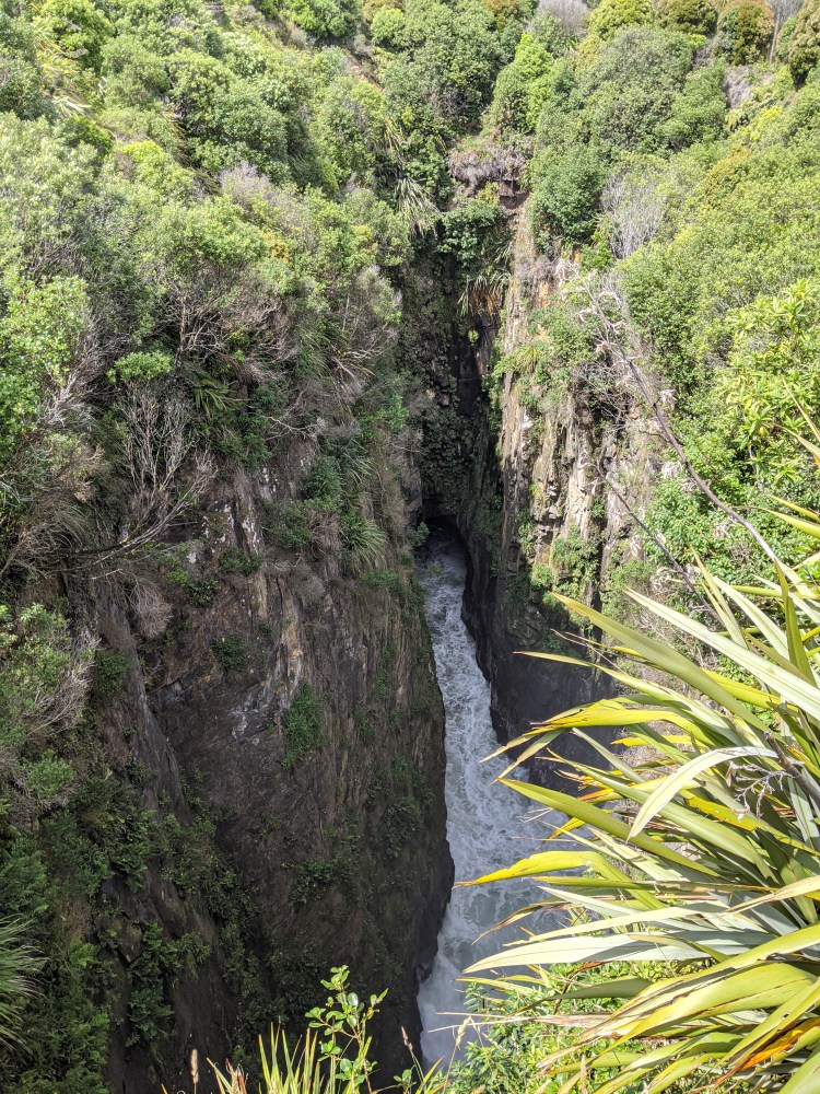
Points R & S are certainly easy on the eyes! However, Purakaunui Falls is very touristy and I wouldn’t recommend lingering around for too long, purely based on how many people will be cramming in next to you just to get the perfect shot. Point T is basically part of the drive anyway and you can pull in anywhere to grab a quick snap and leave. Jack’s Blowhole (U) is slightly further than the other spots and based on the route we took, we managed to go on a bit of a wild goose chase to ultimately realise that we weren’t there for high tide or ‘rough enough’ weather (is anything worth it if it’s not rough enough?) However, if the weather is nice, it’s still worth doing the Jack’s Blowhole walk as it seems a lot shorter than it states on the map and more of a pleasant cliff top stroll.
Points V (Surat Bay) and W (Pounawea) are great little areas to stop off and admire the views from the comfort of your car, accompanied by a bag of Doritos. This is followed by Point X which is a short walk to a Tunnel excavated back in 1895. This ran to Balclutha, the nearby town until 1971. You can dare to walk through this tunnel too, if you’re not afraid of the dark…
The final stops on the coast I would recommend doing the opposite way round, so paying a visit to Z – Kaka Point, which is a short drive from point Y – Nugget Point Lighthouse. Simply because Kaka point is another beach stop and the lighthouse is a perfect finish to the journey along the Southland’s scenic coastline. Again, Nugget Point is touristy but really a sight to see on a sunny, New Zealand day.

As a parting tip, I would suggest keeping an eye out for the ‘Tirohanga’ beach picnic area along the main road and which we stumbled upon, on our way to Nugget Point. It has a little pull in area to stop for a photo with a fantastic seaside setting!

I feel like you forgot to mention the fat cat and the friendly couch surfer 😘
LikeLike
There is a special place in my heart for both of those things 😍
LikeLike